
Kamchatka Peninsula: Volcanoes, Earthquakes, Plate Tectonics and UPSC Geography
Kamchatka Peninsula: Volcanoes, Earthquakes, Plate Tectonics and UPSC Geography
Explore the location, geological structure, volcanic landscape and seismic significance of one of the world's most active tectonic regions.
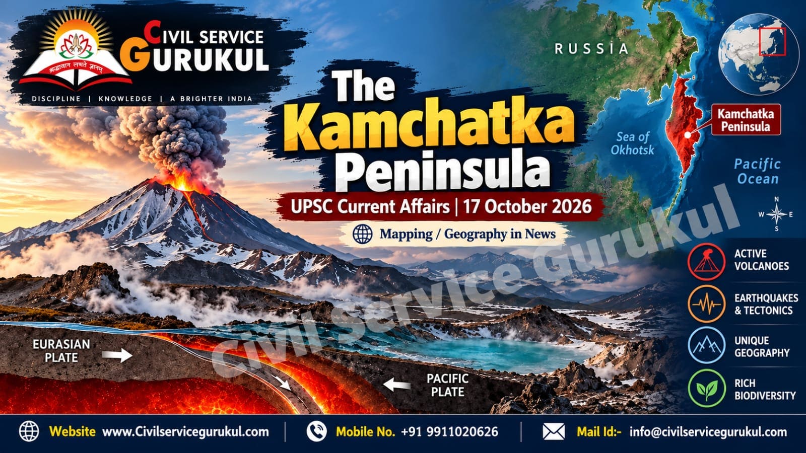
The Kamchatka Peninsula, situated in Russia's Far East, is globally significant for its active volcanoes, frequent earthquakes and dramatic geological landscape. Its location along an active convergent plate boundary makes it an important natural laboratory for understanding plate tectonics and volcanic processes.
Earthquakes in this region are closely connected with the movement of tectonic plates around the northwestern Pacific Ocean. Studying Kamchatka helps UPSC aspirants understand the Pacific Ring of Fire, subduction zones, volcanic landforms and the relationship between tectonic activity and natural disasters.
1. Where Is the Kamchatka Peninsula Located?
The Kamchatka Peninsula extends southward from Russia's northeastern mainland into the northwestern Pacific region. It is bordered by the Sea of Okhotsk to the west and the Pacific Ocean and Bering Sea region to the east and northeast.
The peninsula is known for rugged mountains, volcanic peaks, glaciers, geothermal areas and extensive natural landscapes. Its geographical position near major tectonic boundaries explains its exceptionally high volcanic and seismic activity.
Important geographical features
- Country: Russia.
- Region: Far Eastern Russia.
- Western water body: Sea of Okhotsk.
- Eastern water body: Pacific Ocean.
- Northern connection: Bering Sea region.
- Major geographical association: Pacific Ring of Fire.
2. Why Is Kamchatka Geologically Important?
Kamchatka lies along a highly active convergent plate boundary. In this setting, the Pacific Plate descends beneath the overriding plate system associated with the Okhotsk microplate, generally considered part of the broader North American Plate framework.
This process is called subduction. As an oceanic plate moves beneath another plate, it contributes to the formation of deep ocean trenches, earthquakes and magma that can feed volcanic eruptions.
How does subduction produce earthquakes and volcanoes?
- Plate convergence: Two tectonic plates move towards one another.
- Subduction: The denser oceanic plate sinks beneath the overriding plate.
- Stress accumulation: Friction and plate movement build stress along parts of the plate boundary.
- Earthquake generation: Sudden movement releases accumulated energy as seismic waves.
- Magma formation: Processes associated with subduction promote melting in the mantle above the descending plate.
- Volcanic activity: Magma may rise through the crust and produce volcanic eruptions.
3. The Pacific Ring of Fire
The Pacific Ring of Fire is a broad belt around much of the Pacific Ocean characterised by active volcanoes, earthquakes and tectonic plate boundaries. Kamchatka forms part of this wider geologically active zone.
The Ring of Fire is not a single continuous geological structure. It consists of interconnected tectonic boundaries, including subduction zones, where oceanic plates interact with neighbouring plates.
Why does the Ring of Fire experience frequent earthquakes?
- Movement and locking along convergent plate boundaries.
- Sudden displacement along faults and subduction interfaces.
- Shallow, intermediate-depth and deep earthquakes associated with descending plates.
- Volcanic processes in regions where magma rises through the crust.
Other well-known regions associated with the Pacific Ring of Fire include Japan, Indonesia, the Philippines, New Zealand and parts of the western coasts of North and South America.
4. Major Physical Features of the Peninsula
Volcanic mountain ranges
Kamchatka contains extensive volcanic mountain systems and rugged terrain. The Sredinny Range and Eastern Range are prominent north–south mountain systems. The Kamchatka River flows through a major valley between these ranges.
Klyuchevskaya Sopka
Klyuchevskaya Sopka is one of the best-known active volcanoes in Kamchatka and is generally recognised as the highest active volcano in Eurasia. It is an important example of the stratovolcanoes associated with subduction-related volcanic arcs.
Geothermal landscapes
The peninsula has hot springs, geysers, geothermal fields and other hydrothermal features. These are linked to the region's internal heat and volcanic systems.
Glaciers, rivers and wildlife
Kamchatka's cold climate, mountains, rivers and coastal ecosystems support distinctive biodiversity. The region is known for Pacific salmon, brown bears and diverse birdlife.
5. Why Do Earthquakes Occur Around Kamchatka?
Earthquakes in and around Kamchatka primarily reflect tectonic processes along the Pacific plate boundary and the descending slab. Earthquake depth and magnitude vary according to the location and mechanism of each event.
| Earthquake type | General depth | Geological significance |
|---|---|---|
| Shallow-focus | 0–70 km | Can cause intense local shaking and damage near populated areas. |
| Intermediate-focus | 70–300 km | Often associated with stress and deformation within a subducting slab. |
| Deep-focus | 300–700 km | Occurs within descending slabs under specialised high-pressure conditions. |
These are standard approximate depth categories used in seismology. The actual impacts of an earthquake also depend on magnitude, depth, distance from settlements, local geology and building resilience.
6. Tsunami Risk and Disaster Management
Strong earthquakes beneath or near the ocean can generate tsunamis when they cause significant vertical displacement of the seabed. However, not every large earthquake produces a tsunami.
Major risks in the region
- Ground shaking: Damage to buildings, roads and essential infrastructure.
- Volcanic hazards: Ashfall, lava, pyroclastic flows and volcanic gases, depending on the eruption.
- Tsunamis: Potential coastal inundation after suitable undersea earthquakes or other triggering events.
- Landslides: Slope failures triggered by earthquakes or volcanic activity.
- Infrastructure disruption: Challenges for transport, communications and emergency response in remote areas.
Measures to reduce disaster risk
- Maintain reliable seismic monitoring networks.
- Strengthen volcano observation and eruption-warning systems.
- Develop tsunami alerts and clearly marked coastal evacuation routes.
- Apply appropriate earthquake-resistant building standards.
- Conduct public awareness programmes and emergency drills.
- Improve communication systems for remote settlements.
7. Significance for UPSC Geography
Kamchatka offers a useful case study for several topics in the UPSC Civil Services Examination syllabus.
- Physical Geography: Plate tectonics, earthquakes, volcanic landforms and mountain systems.
- Geomorphology: Subduction zones, volcanic arcs, ocean trenches and tectonic valleys.
- Disaster Management: Earthquake preparedness, volcanic hazards, tsunami warnings and resilient infrastructure.
- Map-based preparation: Russia's Far East, the Sea of Okhotsk, Bering Sea, Pacific Ocean and Kuril Islands.
- Environment: Volcanic ecosystems, geothermal landscapes and biodiversity.
8. Quick Revision Notes for UPSC Prelims
- Kamchatka is located in Russia's Far East.
- It forms part of the Pacific Ring of Fire.
- The region experiences frequent earthquakes and volcanic activity.
- The Pacific Plate undergoes subduction beneath the overriding plate system.
- The Kuril–Kamchatka Trench is associated with the regional subduction zone.
- Klyuchevskaya Sopka is a major active volcano in the peninsula.
- Subduction zones can generate powerful earthquakes and, under suitable conditions, tsunamis.
Practice MCQ
Q. Consider the following statements about the Kamchatka Peninsula:
- It is located in Russia's Far East.
- It is associated with the Pacific Ring of Fire.
- Its volcanic activity is unrelated to tectonic plate movement.
Which of the statements given above is/are correct?
A. 1 only
B. 1 and 2 only
C. 2 and 3 only
D. 1, 2 and 3
Reveal the answer
Correct answer: B. 1 and 2 only.
Kamchatka is in Russia's Far East and forms part of the Pacific Ring of Fire. Its volcanic activity is strongly connected to subduction and regional tectonic processes.
9. UPSC Mains Practice: GS Paper I
“The distribution of volcanoes and major earthquakes is closely linked to global tectonic plate boundaries.” Explain with reference to the Kamchatka Peninsula and the Pacific Ring of Fire.
Suggested answer framework
- Introduction: Define plate tectonics and introduce Kamchatka's location.
- Geological explanation: Describe convergence, subduction and the formation of earthquakes and magma.
- Regional features: Mention the volcanic ranges and the Kuril–Kamchatka Trench.
- Impacts: Explain earthquake, volcanic and potential tsunami hazards.
- Conclusion: Highlight the importance of scientific monitoring, preparedness and resilient infrastructure.
10. Frequently Asked Questions (FAQs)
Where is the Kamchatka Peninsula located?
It is located in Russia's Far East, between the Sea of Okhotsk and the Pacific Ocean, near the Bering Sea region.
Why is Kamchatka prone to earthquakes?
Its position near a convergent plate boundary and the subduction of the Pacific Plate contribute to frequent seismic activity.
What is the Pacific Ring of Fire?
It is a broad zone around much of the Pacific Ocean characterised by active tectonic boundaries, volcanoes and earthquakes.
Which is a major active volcano in Kamchatka?
Klyuchevskaya Sopka is one of the region's most prominent active volcanoes and is recognised as the highest active volcano in Eurasia.
Is every major earthquake in Kamchatka capable of generating a tsunami?
No. Tsunami generation depends on factors such as the earthquake's location, mechanism, depth and the amount of seabed displacement.
Conclusion
The Kamchatka Peninsula is an important example of how tectonic plate movement shapes the Earth's surface. Its active volcanoes, earthquake-prone subduction zone and distinctive physical landscape demonstrate the connection between geological processes and natural hazards.
For UPSC aspirants, the region is especially useful for understanding plate tectonics, the Pacific Ring of Fire, volcanic landforms, earthquake mechanisms and disaster management. Linking map-based knowledge with scientific explanations can improve both Prelims accuracy and Mains answer quality.
Prepare with Mentors Who Cleared the Exam
Get personalized study plans, evaluated answer models, and test series access.