
Shaksgam Valley Dispute 2026: Location, China–Pakistan Agreement & UPSC Analysis
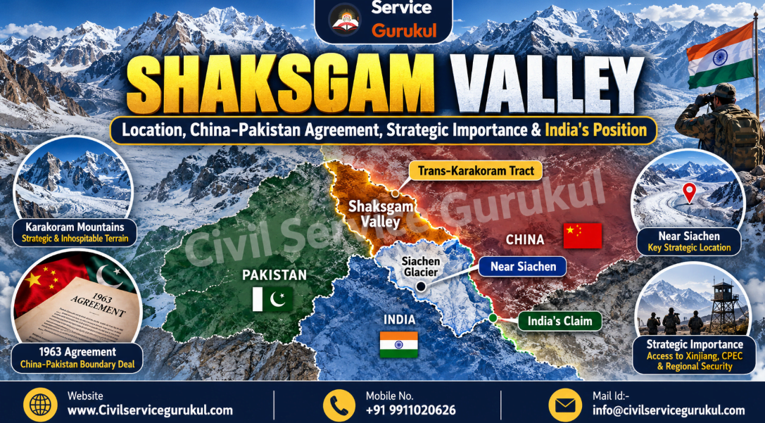
Shaksgam Valley Dispute 2026: Location, China-Pakistan Agreement, Strategic Importance and India's Position
Shaksgam Valley, also known as the Trans-Karakoram Tract, is a strategically sensitive mountainous region in the Karakoram system. Covering approximately 5,180 square kilometres, the area is administered by China but claimed by India as part of its sovereign territory.
The dispute originates from the 1963 China-Pakistan Boundary Agreement, under which Pakistan transferred control of the tract to China. India has never recognised that agreement and maintains that Pakistan lacked the sovereign authority to transfer the territory.
Shaksgam Valley is particularly important because of its proximity to the Siachen Glacier, the Karakoram mountain system and the strategically sensitive India-China-Pakistan region.
- Other name: Trans-Karakoram Tract.
- Approximate area: 5,180 sq. km.
- Mountain system: Karakoram.
- River: Shaksgam River, part of the Yarkand River drainage system.
- Current administration: China, through the Xinjiang region.
- Claimant: India.
- Disputed agreement: China-Pakistan Boundary Agreement, 1963.
- Nearby strategic feature: Siachen Glacier.
- UPSC relevance: Mapping, international relations, border security and strategic geography.
1. Why in the News?
Shaksgam Valley returned to the news in 2026 because of continued differences between India and China over sovereignty and reports concerning infrastructure development in the area.
In January 2026, China defended its territorial claims and infrastructure activities in the region. India reiterated its objections to the disputed transfer of the tract.
The issue again attracted attention in September 2026, when India rejected a China-Pakistan boundary commission involving territory claimed by India.
The Ministry of External Affairs maintained that India had never recognised the 1963 China-Pakistan Boundary Agreement and considered it illegal and invalid.
2. Geographical Location of Shaksgam Valley
Shaksgam Valley is located north of the main Karakoram watershed in a remote, high-altitude and glaciated region of the northern Himalaya-Karakoram geopolitical zone.
The area forms part of the broader Trans-Karakoram Tract and lies near the territories administered by China and Pakistan.
2.1 Relative Location
- North: Xinjiang region of China and the broader Kunlun mountain system.
- South: Karakoram mountains and the Siachen Glacier region.
- West: Pakistan-administered Gilgit-Baltistan.
- East: Other portions of the northern Karakoram and Chinese-administered territory.
2.2 Important Physical Features
The region contains high mountains, steep valleys, snowfields and glaciers. Its severe climate limits permanent settlement and transport connectivity.
Important nearby geographical features include:
- Karakoram Range.
- Shaksgam River.
- Siachen Glacier.
- Saltoro Ridge.
- K2 and the surrounding Karakoram massifs.
- Aghil mountain region.
- Yarkand River drainage system.
2.3 Shaksgam River
The Shaksgam River drains part of the northern Karakoram region and eventually joins the Yarkand River system.
Its headwaters receive meltwater from glaciers associated with the high Karakoram mountains.
2.4 Climate and Terrain
The region experiences extremely cold temperatures, limited accessibility, high elevation and difficult terrain conditions.
Glaciers and snowfields influence drainage patterns, while steep mountain slopes restrict infrastructure construction and regular human movement.
3. Historical Background of the Dispute
3.1 Before 1947
The territory formed part of the northern frontier region associated with the princely state of Jammu and Kashmir.
The broader region had a complicated history of frontier administration, mountain routes, local political relationships and competing colonial-era boundary proposals.
3.2 Accession of Jammu and Kashmir
In October 1947, Maharaja Hari Singh signed the Instrument of Accession, under which the princely state of Jammu and Kashmir acceded to India.
India maintains that the accession established its sovereignty over the entire territory of the former princely state.
3.3 Pakistan's Control of Northern Areas
Following the conflict of 1947–1948, Pakistan established control over parts of the former princely state, including the Gilgit-Baltistan region.
These developments created an unresolved territorial dispute involving India and Pakistan.
3.4 China-Pakistan Boundary Negotiations
During the early 1960s, China and Pakistan negotiated a boundary arrangement relating to areas adjoining China's Xinjiang region.
Their negotiations resulted in the 1963 China-Pakistan Boundary Agreement.
4. China-Pakistan Boundary Agreement, 1963
On 2 March 1963, China and Pakistan signed a boundary agreement concerning the frontier between China's Xinjiang region and territories under Pakistan's control.
Under the arrangement, Pakistan ceded approximately 5,180 sq. km of territory in the Shaksgam region to China, according to the Government of India's official position.
4.1 Major Features
- The agreement was concluded between China and Pakistan.
- India was not a party to the agreement.
- It addressed a boundary involving territory connected to the unresolved Jammu and Kashmir dispute.
- The arrangement included provisions contemplating future negotiations following a settlement of the Kashmir dispute.
- India has never recognised the agreement.
4.2 Why Does India Reject It?
India's position is that Pakistan lacked lawful sovereignty over the territory and therefore had no authority to transfer it to China.
The Government of India consequently regards the 1963 arrangement as illegal and invalid.
5. India's Official Position on Shaksgam Valley
India's Ministry of External Affairs has consistently maintained that Shaksgam Valley is part of Indian territory.
The Government of India states that Pakistan unlawfully ceded 5,180 sq. km of Indian territory to China under the 1963 agreement.
Core Elements of India's Position
- Shaksgam Valley is claimed by India as part of its sovereign territory.
- India does not recognise the 1963 China-Pakistan Boundary Agreement.
- India opposes activities that seek to alter the territorial status of areas it claims.
- India maintains that the Union Territories of Jammu and Kashmir and Ladakh are integral parts of the country.
- India has objected to China-Pakistan boundary arrangements involving disputed territory.
6. Strategic Importance of Shaksgam Valley
6.1 Proximity to Siachen Glacier
Shaksgam Valley lies north of the strategically sensitive Siachen Glacier region.
India maintains military positions along the Saltoro Ridge overlooking the Siachen Glacier sector.
Developments in surrounding areas are consequently relevant to surveillance, strategic planning and high-altitude security.
6.2 China-Pakistan Strategic Cooperation
The tract lies in a region where Chinese-administered territory connects geographically with Pakistan-administered areas.
The growing strategic cooperation between China and Pakistan creates additional security considerations for India.
6.3 High-Altitude Infrastructure
Roads, bridges and logistical facilities in remote mountains can improve access, supply movement and infrastructure connectivity.
Such infrastructure may have civilian functions and potential military significance.
6.4 Karakoram Strategic Geography
The Karakoram mountain system contains important passes, glaciers, high peaks and routes connecting South Asia with Central Asia and western China.
These geographical characteristics make the region strategically important despite its sparse population.
6.5 Sovereignty and Territorial Integrity
For India, the dispute is not solely about the economic value or population of the territory.
It concerns sovereignty, territorial integrity and the legality of boundary arrangements affecting territory claimed by India.
6.6 Link with the Broader China-Pakistan Relationship
Shaksgam Valley is frequently discussed alongside the China-Pakistan Economic Corridor (CPEC) because both involve broader strategic and territorial issues in the northern Kashmir region.
However, the Shaksgam Tract must not be confused with the principal CPEC highway alignment through Pakistan-administered Gilgit-Baltistan.
7. Chinese Infrastructure Activities and Security Concerns
Reports concerning road development and other infrastructure activities in the Shaksgam region have contributed to renewed diplomatic disagreements.
China maintains that its activities fall within territory it administers, while India rejects China's sovereignty claims over Shaksgam.
Potential Security Implications
- Improved access to remote mountain areas.
- Potential changes in regional logistical capabilities.
- Greater strategic sensitivity near the Siachen sector.
- Additional surveillance and infrastructure-monitoring requirements.
- Potential complications for future boundary negotiations.
Infrastructure development alone does not establish an imminent military threat. Its implications must be assessed through verified information, geography and the broader security environment.
8. Shaksgam Valley vs Aksai Chin
Shaksgam Valley and Aksai Chin are often studied together in UPSC examinations, but they are distinct territorial regions with different historical backgrounds.
| Feature | Shaksgam Valley | Aksai Chin |
|---|---|---|
| Alternative name | Trans-Karakoram Tract | Aksai Chin Plateau |
| Approximate area | 5,180 sq. km | 38,000 sq. km under Chinese occupation, according to India's official figures |
| Location | North of the Karakoram watershed | Eastern Ladakh region |
| Current administration | China | China |
| Indian position | Claimed as Indian territory | Claimed as Indian territory |
| Historical issue | 1963 China-Pakistan Boundary Agreement | Longstanding India-China territorial dispute |
| Strategic relevance | Proximity to Siachen and northern Karakoram | Strategic road connectivity between Xinjiang and Tibet |
9. International Law and Territorial Sovereignty
9.1 Sovereignty and Administrative Control
Sovereignty refers to legal authority over territory, whereas administrative control describes the practical exercise of governmental authority.
A territory may be administered by one state while sovereignty over that territory is disputed by another.
9.2 Effect of Agreements on Third States
International treaty law generally recognises that agreements do not create obligations or rights for third states without their consent.
The principle is reflected in Article 34 of the Vienna Convention on the Law of Treaties, 1969.
This principle provides relevant legal context, although the application of international law to a territorial dispute also depends on the history and status of the territory concerned.
9.3 India's Sovereignty Claim
India's objection is founded on its claim to the entire territory of the former princely state of Jammu and Kashmir following accession.
India therefore argues that Pakistan was not entitled to transfer Shaksgam territory to China.
10. Major Challenges for India
10.1 Complex Border Geography
High elevations, glaciers and severe weather increase the difficulty of monitoring and operating in the region.
10.2 China-Pakistan Coordination
Cooperation between China and Pakistan creates additional strategic considerations for Indian border and defence planning.
10.3 Unresolved Territorial Disputes
Historical boundary disputes make diplomatic negotiations and mutually acceptable settlements politically difficult.
10.4 Infrastructure Asymmetry
Differences in road access, transport facilities and logistical infrastructure may affect regional strategic capabilities.
10.5 Environmental Vulnerability
Mountain infrastructure faces risks associated with glaciers, extreme temperatures, slope instability and natural hazards.
11. Way Forward
- Diplomatic Engagement: Continue raising territorial concerns through appropriate bilateral and international forums.
- Border Infrastructure: Improve lawful connectivity and logistical capabilities in Indian-controlled border areas.
- Monitoring and Assessment: Strengthen geographical intelligence, remote sensing and evidence-based evaluation of regional developments.
- Strategic Preparedness: Maintain appropriate defence readiness while prioritising stability and conflict prevention.
- International Law: Consistently articulate India's territorial position through established legal principles.
- Regional Stability: Support peaceful management of disputes and measures that reduce escalation risks.
- Ecological Protection: Incorporate mountain ecology, glacier sustainability and disaster resilience into infrastructure planning.
12. UPSC Civil Services Examination Relevance
| UPSC Paper | Relevant Topics |
|---|---|
| GS Paper I | Karakoram geography, glaciers, mountain systems, drainage and map-based questions. |
| GS Paper II | India-China relations, India-Pakistan relations, sovereignty and international law. |
| GS Paper III | Border management, national security, infrastructure and strategic preparedness. |
| UPSC Prelims | Shaksgam location, 1963 agreement, neighbouring regions, Siachen Glacier and Aksai Chin. |
| Essay | Territorial integrity, peace, border security and the strategic importance of geography. |
- Shaksgam Valley is also called the Trans-Karakoram Tract.
- Its approximate area is 5,180 square kilometres.
- It lies north of the Karakoram watershed.
- It is situated near the Siachen Glacier region.
- China currently administers the disputed tract.
- India claims sovereignty over the territory.
- China and Pakistan signed their boundary agreement on 2 March 1963.
- India has never recognised the 1963 agreement.
- The Shaksgam River drains into the Yarkand system.
- Shaksgam Valley and Aksai Chin are distinct disputed regions.
13. UPSC Prelims Practice MCQs
Question 1
Shaksgam Valley is also known as:
(a) Nubra Valley
(b) Trans-Karakoram Tract
(c) Chang Chenmo Valley
(d) Depsang Plains
Shaksgam Valley forms the major part of the Trans-Karakoram Tract, a territory administered by China but claimed by India.
Question 2
Which countries signed the boundary agreement concerning Shaksgam territory in 1963?
(a) India and China
(b) India and Pakistan
(c) China and Pakistan
(d) China and Afghanistan
China and Pakistan signed the boundary agreement in 1963. India has never recognised the arrangement.
Question 3
Consider the following statements regarding Shaksgam Valley:
- It lies north of the Karakoram watershed.
- It is administered by China.
- India recognises the 1963 China-Pakistan Boundary Agreement.
Which statements are correct?
(a) 1 and 2 only
(b) 2 and 3 only
(c) 1 and 3 only
(d) 1, 2 and 3
Statements 1 and 2 are correct. Statement 3 is incorrect because India has consistently rejected the 1963 agreement.
Question 4
The Shaksgam River ultimately drains into which river system?
(a) Ganga
(b) Brahmaputra
(c) Yarkand-Tarim
(d) Narmada
The Shaksgam River is a tributary of the Yarkand River, which belongs to the Tarim drainage system.
Question 5
Shaksgam Valley is strategically significant partly because of its proximity to:
(a) Nathu La
(b) Siachen Glacier
(c) Gulf of Mannar
(d) Palk Strait
The Shaksgam Tract lies north of the Siachen sector, making developments in the region relevant to India's northern border security.
Question 6
According to the Government of India, approximately how much Indian territory in the Shaksgam region was ceded by Pakistan to China?
(a) 518 sq. km
(b) 5,180 sq. km
(c) 15,800 sq. km
(d) 38,000 sq. km
The Government of India's official position identifies approximately 5,180 sq. km of territory in Shaksgam under the disputed 1963 arrangement.
14. UPSC Mains Practice Questions
"The Shaksgam Valley dispute demonstrates the complex relationship between territorial sovereignty, historical boundary agreements and regional strategic interests."
Examine India's position on the 1963 China-Pakistan Boundary Agreement and discuss its implications for India-China relations.
15 Marks | 250 WordsSuggested Answer Framework
Introduction:
Introduce Shaksgam Valley as a disputed territory in the Trans-Karakoram region.
Body — Key Dimensions:
- Geography and proximity to Siachen.
- 1963 China-Pakistan agreement.
- India's sovereignty claim.
- China-Pakistan strategic cooperation.
- Infrastructure and security implications.
- International law and diplomatic challenges.
Conclusion:
Emphasise peaceful dispute management, diplomatic engagement, territorial integrity and the importance of accurate strategic assessment.
Explain the geographical characteristics of the Trans-Karakoram Tract. How does its location near the Siachen Glacier influence its strategic importance?
10 Marks | 150 Words15. Conclusion
Shaksgam Valley occupies an important place in the strategic geography of the Karakoram region.
Although the tract is sparsely populated, its location near the Siachen Glacier and the territories administered by China and Pakistan makes it geopolitically significant.
The central dispute concerns the 1963 China-Pakistan Boundary Agreement, which India has consistently rejected.
Understanding the issue requires careful distinction between territorial claims, physical control, historical agreements and strategic consequences.
For UPSC aspirants, Shaksgam Valley provides an important case study connecting physical geography, international relations, national security and the principles of territorial sovereignty.
Official Reference and Further Reading
Ministry of External Affairs, Government of India: Official response dated 16 August 2024, describing India's position on the 1963 China-Pakistan Boundary Agreement and the Shaksgam Valley.
Prepare with Mentors Who Cleared the Exam
Get personalized study plans, evaluated answer models, and test series access.